Waging peace
Η κοινοτοπία του καλόυ ~ goodness, too, goes to and fro in the earth.
Total Pageviews
Saturday 28 December 2013
Black Patch Park - striving to renew a place
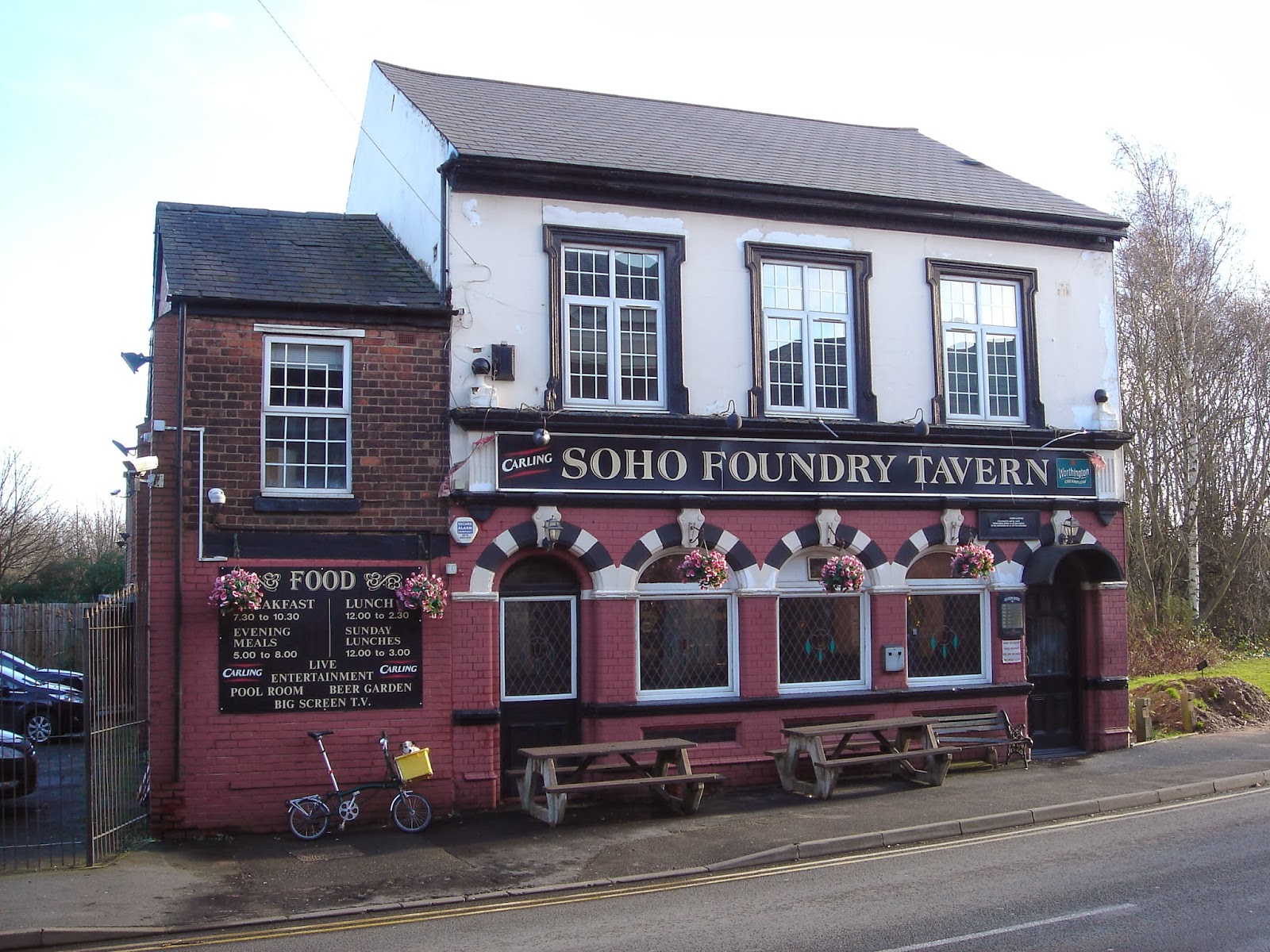
The Friends of Black Patch Park meet in the Soho Foundry Pub. Ron Collins, our Chair, on the left.
Stacey takes us through a CAD-CAM plan for Black Patch Park
A few days before Christmas I met up with my friends Andrew Simons and Phil Crumpton to design a tour of Black Patch Park. They, I and others have campaigned to save and restore this park for over ten years. A mix of protest, with lobbying by letter and meetings - plus the economic crisis - saved the place from ill-judged plans to designate this small green space for industrial building. Vital to the campaign has been the historical research and involvement of the Birmingham and Black Country historian, Ted Rudge. As well as collecting many messages and images from people in different parts of the world who recall childhood on the Black Patch, Ted has documented the enduring link between the Black Patch and the Gypsies...
The Loveridges, descendants of those evicted in 1910, campaigning in 2004, to save Black Patch Park.
...forcibly evicted from the area in the early 20th century to create a park, Gypsies whose descendants a century later joined with the Friends to campaign against building on the Black Patch.
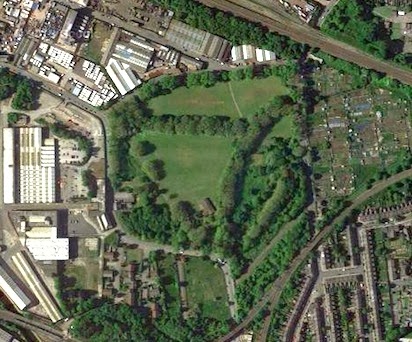
This was from the first Wikipedia piece I wrote about the park in 2006. Black Patch Park and the adjoining Merry Hill allotments are 2.5 miles north-west of the centre of Birmingham on the Sandwell side of the city boundary, surrounded north, east and south by railway embankments. One of these carries the West Coast main line that with the A41 and Birmingham Mainline canal are the arteries, old and new, of what is now known as the city’s 'North West Corridor of Regeneration'. In the centre of Black Patch Park, Boundary Brook, which for centuries marked the boundary between Staffordshire and Warwickshire, meets Hockley Brook, which once separated the country towns of Handsworth and Smethwick.
Black Patch is a green pentagonal edged by Foundry Lane to the west and south, Woodburn Road to the north, and Perrott Street and Kitchener Street to the east beyond which, as far as Handsworth New Road, stretches the fertile triangle of Merry Hill Allotments.
Lying amid intersections, boundaries and important routes, Black Patch Park’s twenty plus acres have a special aura. Sometimes this place can be sunny and convivial, at others times, shaded, misty – especially at first light – and a little eerie; one moment a serene and peaceful place full of birdsong and the sound of breeze in the trees, another moment full of human activity and passing trains seemingly on every side.
Of course revisions removed all those unreferenced 'opinions' - quite rightly. I have not mentioned Kitchener Street which marches along the south west border of the Black Patch. It was once lined by terraced houses. These were demolished in 1980. Kitchener Street was gated in January 2009 under Section 129A of the Highways Act 1980 - a measure intended by Sandwell MBC to prevent fly-tipping along its length.
Kitchener Street in 2008
Phil and Andrew met me near the bridge in the centre of the park. I followed them with pencil and notebook as we discussed suitable places to stop and talk about an aspect of the park...
Philip and Andrew by the bridge at the junction of Boundary and Hockley Brooks - 22 Dec 2013
A WALK AROUND THE BLACK PATCH (first draft)
Notes prepared by Simon Baddeley, Phil Crumpton and Andrew Simon - for the Friends of Black Patch Park on a meeting in the park on Sunday 22 December 2013 to plan a visitors’ tour of the park
1. “Where we stand”, 52° 29.899', -1° 56.650' The bridge. Our tour starts at the ancient boundaries of Anglo-Saxon lands, where two streams meet...
...Hockley Brook and Boundary Brook. Bridged now; once a ford...in an area where a hundred and fifty years ago 'the earth seems to have been turned inside out.'*
The Black CountryKaulo = a Romany word referring to a common or heath, a term which is said to have originated with the large black waste lands about Birmingham and Staffordshire...in 1830 James Nasmyth, a pioneer of the machine tool industry, walking across the area, wrote...'The earth seems to have been turned inside out. Its entrails are strewn about; nearly the entire surface of the ground is covered with cinder heaps and mounds of scoriae. The coal which has been drawn from below ground is blazing on the surface. The district is crowded with iron furnaces, puddling furnaces, and coal-pit engine furnaces. By day and by night the country is glowing with fire, and the smoke of the ironworks hovers over it. There is a rumbling and clanking of iron forges and rolling mills. Workmen covered with smut, and with fierce white eyes, are seen moving about amongst the glowing iron and the dull thud of forge-hammers. Amidst these flaming, smoky, clanging works, I beheld the remains of what had once been happy farmhouses, now ruined and deserted.'
Boundary Brook in summer
2. Black Patch and the Gypsies - "magic hanging in the air"52° 29.950', -1° 56.673' On the rough path into the park just off Woodburn Road and opposite Anne Road. Here we speak of the Industrial terrain of the Black Country – high undulating banks of slag, foundry waste. Detritus and oily trickling waterways – and learn about the Gypsies with Black Patch Park and how they were violently evicted from here in order to found Black Patch Park in 1905.
We chat with Michelle and Bridget and families on the Black Patch in June 2011
The story, as told by Ted Rudge, of Queen Henty and her husband. Her curse on anyone who builds on the Black Patch. (Her ghost - scroll down this 2011 blog entry to read an account)
Queen Henty
Bryn Phillips "Queen Henty might put a curse on you"
3. From a place to a limbo,52° 29.929', -1° 56.821' Standing on the pavement next to the park just where the Hockley Brook passes under Woodburn Road. What was once a ‘place’ before the industrial revolution and continued as a space between factories for dumping waste and as a Gypsy settlement has, post-industrialisation, become almost a non-place, its surrounding factories mostly derelict and the surrounding population, once its users, decanted from the area. This is the challenge for the future of the Black Patch, on the boundary of two local councils, to be better recognised as a stewarded public space. recalled with nostalgia by people who once lived by, and played in the park.
4. The Old Main Entrance to the Black Patch, 52° 29.916', -1° 56.848' From a position just inside a corner of the park where Woodburn Road meets a bend in Foundry Road. An avenue of mature London Plane trees runs south-east against a background of Grey Poplars lining the Boundary Brook on the other side of the main playing field. This is one of the finest views of a typical late Victorian Park, snowy black and white in winter; a feast of greenery in summer. and...
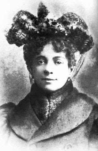
...if you gaze slightly right from the tree-lined avenue, you glimpse a long mound, intended over a decade ago, to be a BMX track. Just before that, covered by greenery is all that remains of the small cottage that was the home of Mrs.Hill. Before the cottage was built, this was a camp-site - parking for a vardo in which Hannah Chaplin, née Hill, gave birth, in 1889, to a baby boy.
Charlie Chaplin by Peter Ackroyd, Chatto & Windus: London 2014, p.4
Transcript of a particular letter that Chaplin, who received millions of letters, kept on its own in a locked drawer
Charles Chaplin had his upbringing - a difficult one - in south London, but unless there's credible rebuttal, Smethwick's Black Patch, rather than London's Southwalk, has become the great comedian's strongly rumoured birthplace - 52°29'53.3"N 1°56'49.6"W
Hannah Chaplin, née Hill
The Chaplin birthplace conjecture was artfully fuelled in the TV series Peaky Blinders, series 2, episode 5 (2013) - creator and writer Steven Knight:
"...I was a bookie in Birmingham, then he went to Los Angeles.
You see, Wag is also a Romany Gypsy, as is Chaplin.
But he keeps it a secret. Chaplin was born on the Black Patch, a Gypsy camp in Birmingham..."
Back to the future 2/8/15: I made a video recording on Sunday 26th July 2015. It shows Ted Rudge, author of Brum Roamin' and Charlie Chaplin's son, Michael Chaplin, visiting Black Patch Park. The clip records a gathering of Gypsies and friends at the bridge in the centre of Black Patch park, where a memorial has been set up, recording the association of Romany with the Black Patch. Michael Chaplin speaks of his belief that his father was born here....
5. The Coppice, 52° 29.811', -1° 56.726' Having strolled down the SE avenue, we stop where the path divides, to meet an exit into Foundry Lane just before the Soho Triangle of the old LNW Railway or north east along the edge of Boundary Brook. This was a confluence of local population, industrial buildings and parkland; the park ill-tended; the population dispersed; the industry departed. There are views to be restored, easy to see with a selective cutback of shrubbery and windfall saplings, of the Victorian railway viaduct and embankment to the south, old industrial roof tops to the north west and, due east, the distinctive square redbrick tower of Bishop Latimer Community Church.
The coppice
6. Warwickshire triangle52° 29.879', -1° 56.625'. We stroll north east along the west bank of the Hockley Brook the main playing field on our left, cross the bridge, and enter the overgrown area of the Black Patch bounded by Perrott Street and Kitchener Street where there was a Primary School whose playground markings and concrete turtles still show through brambles and brush, the space so overgrown it is near impossible to see the older tree lines. There’s an entrance to the park off Perrott Street which brings you to a small undulating green sward, isolated from the rest of the Black Patch.
Warwickshire Triangle
7. The Main Playing Field, 52° 29.875', -1° 56.728' Walk back across the bridge and head south west to the centre of the main playing field. Here is an opportunity to gaze about at the original space that was created by John Nettlefold's Birmingham Playgrounds, Open Spaces and Playing Fields Society to meet the needs of the new industrial population that surrounded the Black Patch. It is an area that is still much used by footballers of the Warley League.
8. Soho Foundry, 52°29'50.46", -1°56'50.94" Stand beneath the imposing gateway of the Soho Foundry, opposite its eponymous pub where the tour can end with a drink and snack. This place is a prime target on the 1940s German air reconnaissance maps - some of them which we saw in the Avery Historical Museum entered below this gateway – the centre of an industrial hive.
Black Patch Park is closely NW of the 3 parallel roads - Wills, Markby and Preston - at the lower right hand corner of the 1940s Luftwaffe reconnaissance photo
It is also where our tour might continue - exploring the remains of the Soho Foundry and, still standing and part-used, the 19th century houses, first to be lit by gas.
Andrew and Phil
Black Patch Park was saved from building, but it remains a blighted and derelict space
*E-mail from Phil Crumpton on 15 Feb 2014 re that place in Black Patch Park:
Hi, Simon...Mercia before William Conqueror, Kingdom of Mercia was almost the monopoly of England outside Essex, Wessex, East Anglia and Kent with Sussex. Western area was mostly Welsh border and still to be tribally fought over.
WHERE BLACK PATCH ( then Handsworth Plain and Pre-'Smithwick' ) ended up as a camping site for Roma was to form a later eastern boundary to pre-date the convergence of Staffordshire; Worcestershire and Warkwickshire. That's where we (3) stood on the bridge as the brooks joined up in the park. We have to work on County Boundaries that also differentiate the site from the Norsk Invasion period that saw so much pre-industrial fallowness. People were more welcome to 'live' at the Patch in those times than they are accommodated, today...!
Let me know what you think. Watching (videoes) and brushing up on my Smith Wick knowledge over this weekend. See you on tuesday night at the AGM where I think there's likely to be many hours of lively discussion. Phil.
If I was adding to points on this tour I'd include the way in and out of the area that brings a visitor to Black Patch Park via the Birmingham Mainline Canal towpath, up Avery Road to meet Foundry Road - a hedged path almost a tunnel - 52.495691, -1.947895 - at the bottom of the Avery Road cul-de-sac. It leads about 100 yards via a couple of kinks to and from the waters of the canal and its towpath back two miles or so eastward into Birmingham or six or seven miles westward to Wolverhampton.
The path to Black Patch Park from the canal
Cycle and walking path from Avery Road to the canal towpath - a Sustrans route
*** *** ***
My longing for Greece is palpable. In days from the cold Adriatic I shall touch the concrete at ugly Igoumenitsa Port. We'll walk a kilometre to the ferries for Corfu.
A view from Ano Korakiana - the ferry from Venice to Igoumenitsa in the centre of the Kerkyra Sea
The Philharmonic Christmas Concert on Sunday, December 29, 2013, is in the church of St. George, in our village στο χωριό μας.... Χριστουγεννιάτικη Συναυλία Η Χριστουγεννιάτικη συναυλία της Φιλαρμονικής την Κυριακή 29 Δεκεμβρίου 2013, στην εκκλησία του Άη-Γιώργη, στο χωριό μας.
*** *** ***
These last few months have been spent working on the soil of my allotment. I've invested in manure and topsoil and paid someone younger and stronger than I to spread and dig it in. My neighbouring plots seem neglected, even for winter, after small bursts of enthusiasm earlier in the year...
These allotments are sketches of achievement and shortcoming; aspiration and lethargy. How appropriate that the word ‘plot’ also means 'story'; in mine and my heighbours' cases. biographies - more complicated than the original purpose, which was an allotted piece of ground off which a working man, often an émigré driven from the countryside, could feed his city family. These allotments test more than our craft as gardeners. Standing on my rented ground I gaze hopefully at a mirror.
The shed came free. We got it for the cost of transport via Freecycle. I repainted it, re-roofed it and added a veranda. Inside it's neat. I keep only hand tools there, most hung neatly on hooks. My neighbour's bees, to the west of the shed, are surviving the winter so far. We continue to take out couch grass, removing the spreading white roots and their rhizomes. Some of the plot is covered in black polythene - bringing the couch roots to the surface for elimination. Just to the east of the shed, four builder's bags are composting green waste. There's a water tank beside the shed door - a gift from a neighbour. The whole plot has been deep dug over several times. The collection of middle sized stones is getting larger as these are sifted out and separated from the soil. They're flattish and round, a reminder of how millions of years ago a wide warm river ran through this part of the world, Our five fruit trees have survived another year. We are half through the fourth year of the tenure for which I signed on the Victoria Jubilee Allotments. My plot is just acceptable; just satisfactory; clearly being worked. Having campaigned ten years to prevent the whole area being used for building, this is a small island in which I rejoice.
June 2010 - Adrian Stagg welcomes new gardeners on the opening days of the VJA


No comments:
Post a Comment